If you landed on our article only with the intent of finding the best online map of Venice, we believe that your best option is Google Maps, with the Satellite Layer enabled.
If, however, you want to know more about Venice maps and learn a few tricks that will help you get around, keep reading our article!
The Map of Venice
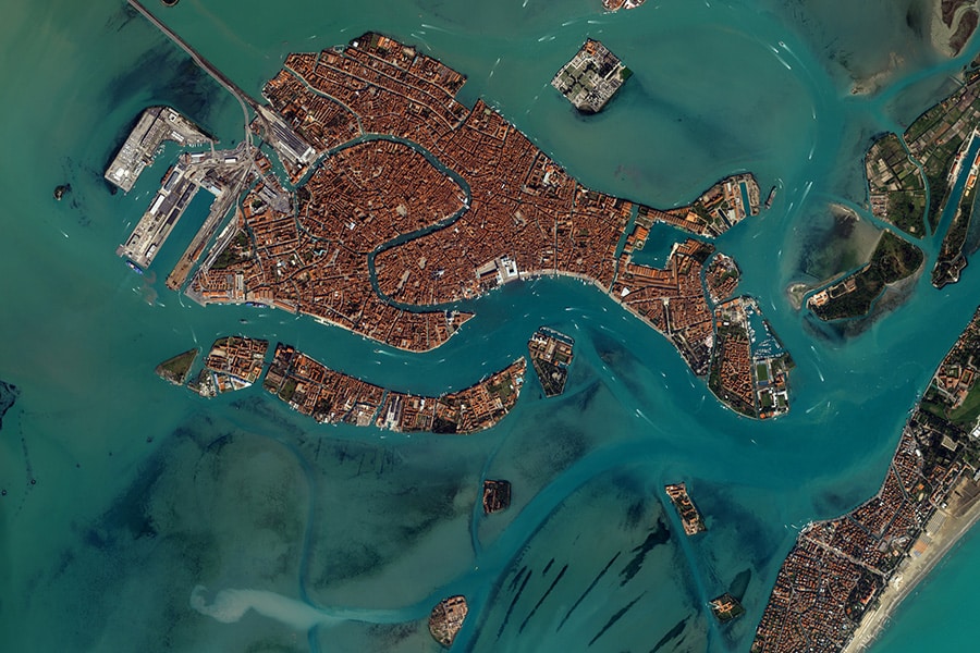
It is a redfish made of houses?
Is it a maze floating on the ocean?
These are two questions that could come to your mind when looking at a map of Venice for the first time.
Although it is obvious that Venice is not a fish nor a maze, it is also true that Venice is unlike any other city in the world.
Its aspect can be as confusing when seen from above as it is when walking through its narrow alleys.
We created this article to get rid of any obstacles you might find in understanding how to move around the city.
On one side, we introduce you to the morphology of Venice and other general information, on the other we provide you with tips, tools, and resources to move around the city.
Are you ready? Let’s go!
Want more tips, tools and stories from Venice, Italy?
We're on a mission to make it easy and fun to discover and support the authentic Venice. Try our email and see for yourself!
Before being able to read a map of Venice and move around, it is crucial to understand how the city of Venice is made.
The first step to understanding a map of Venice
To understand how to move around Venice, we must understand how this unique city was built.
How was Venice built?
Venice is an ancient city measuring less than 8 square km, which is located in the middle of a shallow Lagoon.
Venice was built over the centuries on top of 117-118 little islands very close to each other that were just above the water level. On each small island, Venetians built a church, a square, a well, and the houses of those inhabiting it.
Only after the construction of the islands did the Venetians start building bridges, to connect the islands one to another physically.
These facts, introduce and answer the following (very popular) question.
Why does moving around Venice feel so complicated?
Since the buildings and alleys on every island were built without taking into consideration the design of the other islands surrounding it, the streets of neighboring islands are hardly ever aligned with each other.
As a consequence, there are almost no straight routes to move across the city!
Now you know why, looking at a map of Venice, you get the impression to be looking at a gigantic maze.
Related: What is Venice, Italy
Book an authentic experience in Venice
See all experiencesNow that you know how come Venice is surrounded by water, has canals, and looks like a maze, you are ready to examine and understand the map of Venice.
The Map of Venice
As mentioned above, at first glance the map of Venice may look like a fish made of houses floating in the middle the sea.
Actually, that description is sort of correct.
The map of Venice resembles a fish, its head on the left where the train station and the parking lot in P.le Roma are, its tail on the right where the Giardini and the Arsenale are.
The surface of Venice is almost entirely covered by human constructions, relatively small parks and gardens being the only exceptions.
Venice seems to be floating in the middle of the sea if looked at from a map, but… but that is not correct. Venice does not float on water, and the water surrounding the city is not a sea.
As mentioned before, Venice was built on little islands that were surfacing the shallow water of an almost entirely enclosed and calm body of water called the Venetian Lagoon.
But what else can we see when looking at a map of Venice?
One of the first things we can immediately spot by looking at a map of Venice is that a big canal seems to divide the city into two parts: a part on the top-right of the map, and one part on the bottom-left.
The Grand Canal in Venice
Venice has over 180 canals, but only one of them is called Grand. That is, of course, the Grand Canal.
The Grand Canal is over 4km long and has a width between 30m and 70m. It runs through the entire city of Venice, dividing it into two parts.
For almost 400 years these two halves of Venice had no physical connection with each other, and the only way to cross was via boat.
Only in ~1175 C.E., almost 400 years after the first settlements in Venice, did the Venetians build a pontoon bridge to connect these two sides of Venice.
In the same location, in 1588, Antonio da Ponte built what became the first, most important, and most famous bridge in Venice, the Rialto Bridge.
Today, there are four bridges crossing the Grand Canal and connecting the two halves of Venice.
Related: Everything you ever wanted to know about the Grand Canal in Venice, Italy
Is Venice divided in two?
No, trice that! Yes, Venice is divided in “sestieri,” six districts.
While the map of Venice shows a town divided only into two parts by a big waterway called Canal Grande, the city is historically divided into six districts, three on each side of the Grand Canal.
These six parts are the districts of Cannaregio, San Marco and Castello on the top and right of the map, and Dorsoduro, Santa Croce and San Polo on the center and bottom-left.
At the time of the Republic of Venice, the Serenissima, every district nominated one ducal councilor to assist and control the Doge of Venice, the head of state of the longest lasting Republic in history.
Related: How to create and run the longest-lived form of government ever: the case of the Republic of Venice
Historically there were rivalries between the districts of Venice, and today some light teasing still occurs regarding which is the best district in Venice. We honestly think it’s quite silly, as it is pretty obvious to us that the best sestiere in Venice is Cannaregio (where we live), of course!
Unlock a discount at the best local businesses in Venice
Learn more about Venezia Autentica Friends' PassHas the map of Venice always looked like this?
As we mentioned before, the city was built over a long period and its its look evolved over time. However, since the lagoon counted only a limited amount of islands, all the available space was soon occupied by the buildings.
Does this mean that the way Venice is today is exactly the way it was hundreds of years ago?
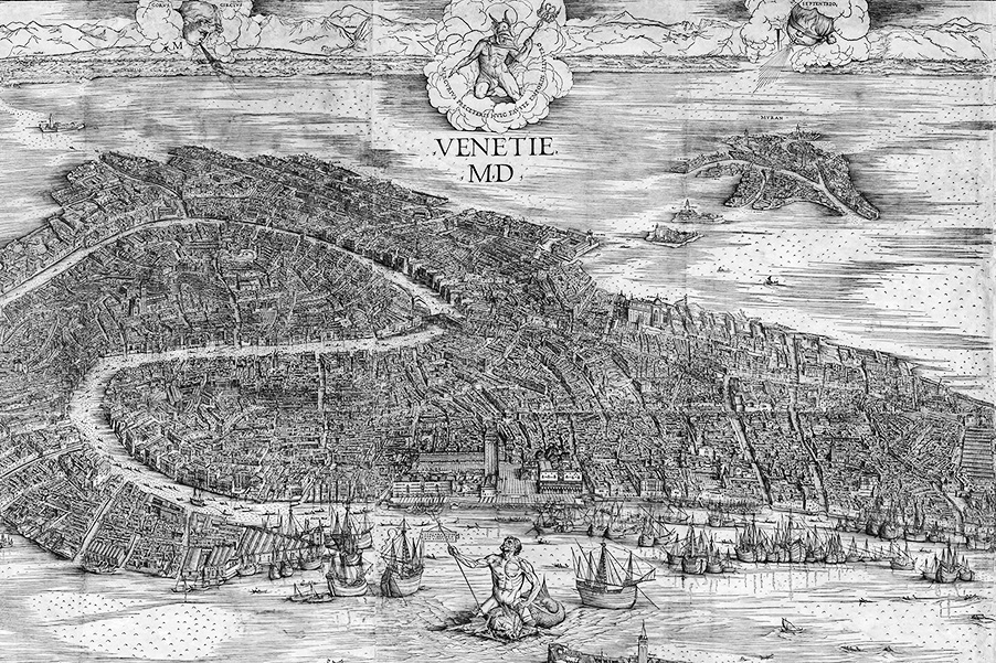
Not quite. To see how Venice changed, the best thing to do is to look at the most famous map of Venice, the “Veduta di Venezia”, the “View of Venice”, by Jacopo de’ Barberi. This map of Venice, created in 1500, is a gigantic woodcut made on 6 panels which measure a total 1,3 m x 2,8 m!
What is immediately apparent, is that 500 years ago Venice had gods and monsters fighting in Saint Mark’s Basin… ehm… [Fool-Mode OFF]
By comparing the Jacopo de’ Barberi map with a current map of Venice the thing that strikes us most is that, today, there seem to be fewer canals than in the past. As you can see, in some areas the map of Venice by de’ Barberi shows canals, where today there are streets instead.
Why are these two maps of Venice different? Did De' Barberi make a mistake?
Since the buildings and alleys on every island were built without taking into consideration the design of the other islands surrounding it, the streets of neighboring islands are hardly ever aligned with each other.
As a consequence, there are almost no straight routes to move across the city!
Now you know why, looking at a map of Venice, you get the impression to be looking at a gigantic maze.
Of course not! These two maps of Venice are different because, indeed, some canals have been transformed into walkable ways.
A canal that was turned into a street is called “Rio Terà,” where “rio” is the correct term for canals in Venice (Canal Grande, di Cannaregio, and della Giudecca are the exceptions) and “terà,” interrato, means “filled in with earth.”
Next time you look at a map of Venice, and you read the name “Rio Terà,” you will now know that there once used to be a canal!
Related: All the bad things Napoleon did and all Venetian know very well about! <– Article available soon
Now that you know a few more things about Venice, the way it was built, and why maps of Venice look like a maze, you’re ready to learn a few more things and some tips to best move around Venice.
Tips on moving around Venice
There are a few tips as well as some tools that help you to walk around Venice. Each of them has pros as well as cons, and it’s a good idea not to rely entirely on a single one to understand where you are in Venice and how to reach your destination.
Paper map of Venice:
Until recently, paper maps were the only kind of map of Venice available.
The most important feature of paper maps is the fact that they can be easily stored and carries and don’t need a device nor internet connection to access them.
However, paper maps of Venice also have two problems.
The first problem, which is common to all paper maps, is the lack of indication about where YOU are at a specific moment.
The second problem, which is less obvious, it that maps of Venice lack details. While Venice is just below 8 square km, its 2650 alleys, 433 bridges, and 182 canals are just impossible to fit into a map small enough to carry around and check at any time.
As a consequence, while paper maps of Venice are light, inexpensive, and don’t need a battery, they also oblige you to spend some time finding your location on the map, and they also can help you only up to a certain point, since they lack the detail that digital maps have.
Digital map of Venice:
We just mentioned one of the qualities of digital maps: detail!
On a digital map of Venice, you can zoom in all the way until you see wellheads on the squares and gondolas on the canals. Isn’t that amazing?
That’s not the only advantage, though. Digital maps also show your location with the click of a button, tell you how to go from point A to point B in real time, and they are for free!
Related: on Google Maps you can make us of a highly detailed map of Venice for free
Ah, technology is so cool! You can rely on it 100% of the time in everyday’s life as well as when traveling… until you can not. Wait, what?!
You read that right. We sure love Google Maps’ speed, ease of use, and everything else. Unfortunately, however, it needs a decent GPS signal for working, and that is often not the case in the very narrow alleys of Venice!
Venice is a unique and complex city. Therefore even Google struggles to provide users with clear directions and ways to get to a destination.
Therefore, you should see all Google Maps information as indicative.
If you have doubts about how to get to a particular place, don’t hesitate to use Google Maps and to politely ask for help to the people who know Venice the best: the Venetians!
Street Names and Signs:
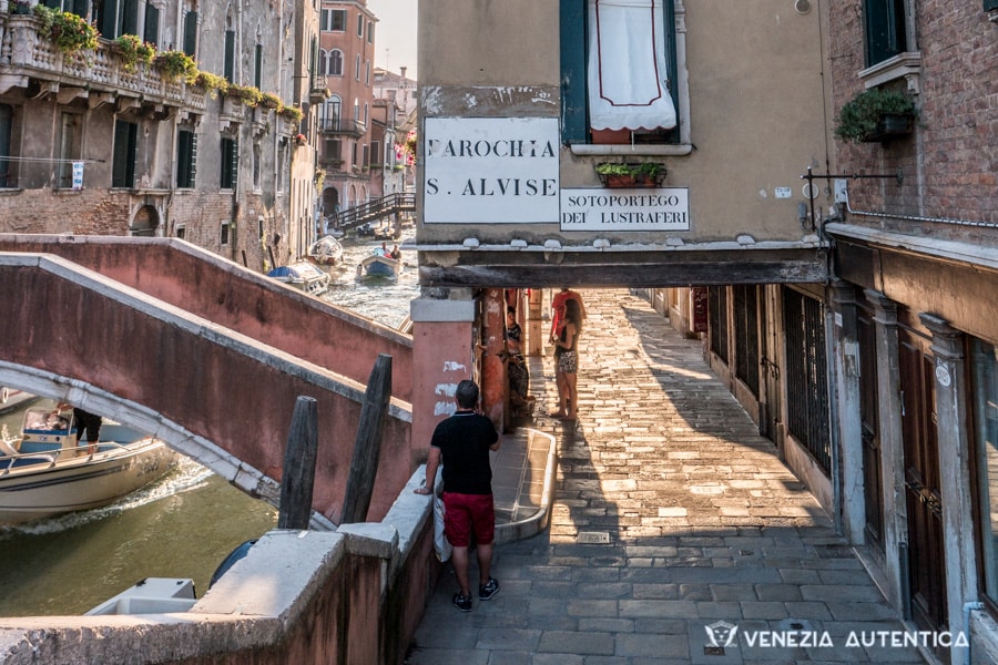
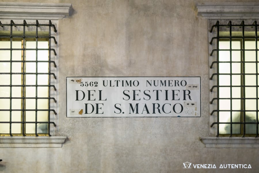
Street names in Venice are painted directly on building walls, on white plaster surrounded by a black frame. In Venetian, they are called “nizioleti”, which means “small bed sheet”.
While nizioleti are now part of everyday life in Venice, they exist only since 200 years, after the end of the Serenissima.
In fact, for over a thousand years street names existed but were not written anywhere and were handed down orally. When Napoleon took over Venice, he demanded the new administration to record the names of all the alleys in and write them on the walls, making it easier for non-Venetian to move through Venice.
Street names, just like digital and paper maps, also present problems of their own. In Venice, in fact, many alleys around the city use exactly the same name! Just a few examples are the 31 different “calle del forno”, 16 “calle del magazen” and the 16 “calle dei preti”. This ambiguity required to develop a house numbering system that is quite bizarre and causes a lot of headaches.
In more recent years, also street signs started appearing upon walls around Venice.
While these signs are easy to read and understand, they indicate only how to reach five important locations in Venice: San Marco, Rialto, Accademia, Train Station and Piazzale Roma (parking lot).
If you need to go anywhere else, well, don’t count on them!
Landmarks are your stars:
Venice has always been a city of merchants and sailors, so you shouldn’t be surprised if we encourage you to learn how to navigate the city following the stars.
Rather than stars, however, a trick for navigating through Venice is to make use of landmarks.
There sure are plenty of what people traditionally call “landmarks”, but the alleys in Venice greatly outnumber them.
This is why, for Venetians, anything can become a “landmark” to explain to each other where to meet.
When giving directions to each other, Venetians don’t just use famous landmarks such as the Salute Church, the Rialto bridge or Saint Mark’s, as there would be too few of them.
So, a landmark can be a supermarket, a school, a pizzeria, restaurant or clothes shop popular amongst the locals.
i.e: “ti ga presente ea Maria dele pissette? Ecco, ea caleta de fronte, dopo el frutariol Bepi!”
“you know Mary(‘s shop) who makes small pizzas, right? The small alley just in front of it, after the fruit and vegetable seller Bepi”
This way of navigating through the city, which is very common today, was even more popular at the time of the Serenissima when there were no street names nor signs on the walls.
In fact, “nizioleti” would have been of little help to the many people who could not read back in those days!
Instead, recognizing a church, a wine bar, or a famous apothecary would help locals orientate themselves and know exactly where to go.
Related: The Rialto head which was meant to be seen, and you didn’t notice
Know your direction:
You now know the usefulness as well as the limits of paper maps, digital maps, and street signs, and how to make use of landmarks to move around Venice.
We also mentioned the importance of understanding how the city was made and of having a mind map of Venice. That is an essential step not only for being able to use digital and paper maps proficiently but also to being able to walk around the city like a Venetian.
Locals don’t necessarily need to know every corner of the city to be able to walk around. Venetians just need to know the “direction” of their destination to be able to reach it.
The trick for walking around Venice as if guided by an invisible compass, in fact, is to visualize which way your destination is and remember that there are no straight lines for reaching it (now you know why we spoke of the importance of having a mind map of Venice!)
We realize it might sound complicated but, with a bit of practice, it’s not too difficult to learn how to best navigate through the Venice maze:
Know where your destination is on the map.
Know which direction it is, from where you are.
Know that there are no straight lines to get there.
If you ask locals for directions, the address number won't help you:
You’re looking at your map of Venice, you are using all the tricks you know, yet you can’t seem to get where you want? Well, you can ask a local for help, of course.
To do so, however, there is something you should know: don’t even mention the house number. Here’s why…
For over a thousand years, Venetians didn’t have house numbers.
However, in the XIX century, after Venice became part of the Austrian Empire, a house numbering system was put into place. Fabulous, right? No, not at all!
House numbers in Venice make no sense, at all. Not even to the Venetians, trust us.
Unlike anywhere else, in fact, the numbers do not “reset” for every alley but grow throughout a district instead.
This means that one building somewhere in a district is numbered “1”, and the other buildings are numbered “2”, “3”, and so on… all the way up to “6828” as is the case of the Castello district!
As a consequence, if you ask a local for “Cannaregio, 4621”, he will shrug his shoulder and say “I’m sorry, I don’t know”.
Instead, make sure to check out which landmark or church is closest to your destination and ask a local how to reach it. He/she will then be able to give you the right directions to get there.
Once you are close to your destination, someone living or working there will be able to tell you how to reach the alley you’re looking for.
You now know everything there is to know to move by foot around Venice. But what if you want to use public transportation?
Well, in that case, it is useful to learn a few things about how public transportation lines serve the city.
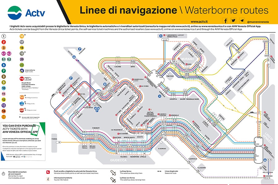
Public Water Transportation Map of Venice:
Don’t be scared by this particular map of Venice you can see below. The way the water transportation system in Venice works is pretty simple and quite efficient.
Download: Public Water Transportation Lines in Venice Map in HD
Explanation of the public water transportation lines:
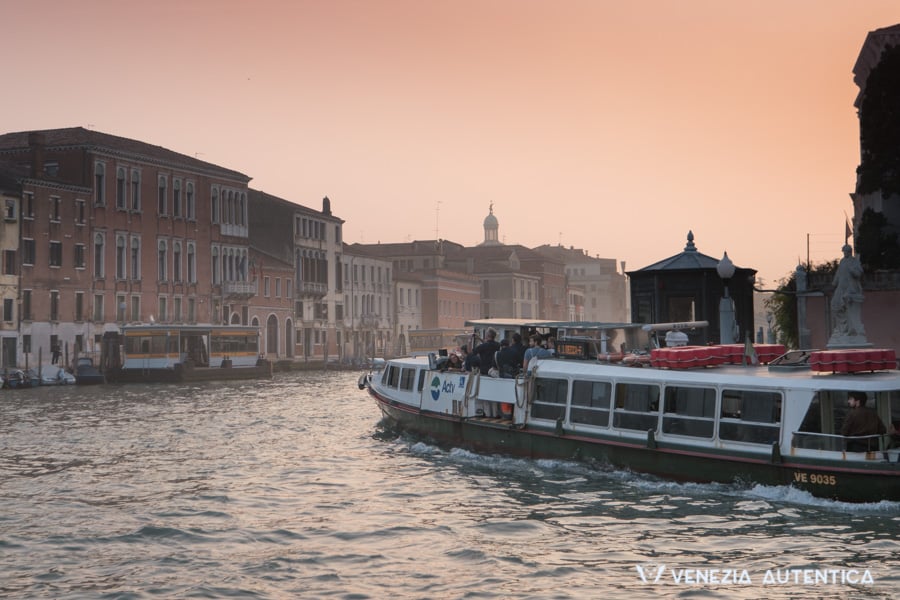
Because Venice is so densely built, the relatively big public transportation boats can only navigate either around Venice or on the Grand Canal, the most important canal in Venice, which passes in the middle of the city.
Related: Everything you ever wanted to know about the Grand Canal in Venice, Italy
Main public water transportation lines through the city:
The main lines on the Grand Canal are line number 1 and line number 2.
Line number one navigate from one end of the Grand Canal all the way to the Lido, and the opposite direction as well. It halts at every single stop.
Line number 2, which also goes both ways, stops only at the most trafficked stops on the Grand Canal and ends at San Marco Vallaresso. (Line number 2 continues all the way to the Lido in the summertime.)
Pay attention, if you take Line number 2 from San Zaccaria station, you will navigate AROUND Venice, on the Giudecca Canal.
Main public water transportation lines around the city:
4.1 (and 4.2): This line Leaves from “F.te Nuove” in Venice. It goes straight to Murano, circles around Murano, comes back to Venice, circles around Venice including Giudecca, and ends back at F.te Nuove.
Line 4.1 goes counter-clockwise. 4.2 goes clockwise
5.1 (and 5.2): Leaves from Lido, circles around Venice including San Marco (San Zaccaria), and ends back at Lido
Line 5.1 goes counter-clockwise. 5.2 goes clockwise
What about the other lines? How do I get from this station to that station? At what time do they leave? How long does the ride take?
Don’t worry. There is a simple solution to all these questions…
Chebateo, a very handy website and app service:
Chebateo is an easy to use service, available both as a website and as a phone app on Android phones and on iPhones, which tell you exactly which lines you need to take to go from one stop to another.
Just type in the station from which you leave, the one you want to reach, and the desired time of departure. The service will tell you which line(s) you need to take and the total length of the journey. Easy!
And, of course, now comes the most important resource of them all: the map of Venice we created to help you all discover the city and make a positive impact on the lives of the locals by supporting local businesses!
Venezia Autentica's Interactive Map of Venice
Our interactive map of Venice displays our selection of authentic local businesses where to eat, drink, and shop as well as famous Venetian landmarks, points of interest and fabulous view points.
This map of Venice was created to complement our work and mission by making it easier for you to get the best our of your stay in Venice and discover the authentic Venice, while supporting quality local businesses.
Every pin on our interactive map of Venice is linked to its page on our website, and it can be accessed with 1 click. There, you will find a description and pictures, as well as useful information such as the exact address, telephone numbers, opening times, etc.
As of today [January 2019], our interactive map of Venice already counts almost 200 locations (and the pages linked to them!), but our work is still in process.
We recommend to bookmark the “Interactive Map of Venice” page, to have a quick access to the map of Venice and hundreds of locations from which to chose from!
We hope that our article gave you all the tools you need to make use of any paper, digital, and interactive map of Venice.
Now, before you plan your trip to Venice, make sure to check out the resources below to make the best out of your time here:
I'm visiting Venice. Why should I follow your recommendations?
The way you visit Venice has an impact both on the quality of your experience and on Venice itself. Chilling, exploring, shopping, eating and drinking where the locals do, can make a huge impact both on the memories you bring home and on the local economy and community.
POPULAR POSTS LIKE THIS
Best Places where to eat and drink like a local in Venice
Interactive map of the best authentic local businesses and places where to eat & drink in Venice
Why eating and drinking at authentic local businesses matters
Home >> Visiting Venice >> Tips and Inspiration >> You’re Here
Tips and Inspiration to experience Venice
More in Visiting Venice
Go to Visiting Venice >>

